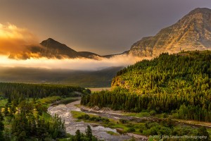
About 15 years ago I discovered an artist that painted simplistic scenes of abandoned houses on green plains with grand skies. There was something about the paintings that really appealed to me, perhaps the simplicity, but also the primitive nature of the scene. It was a few years later that I became aware of the “Palouse”, an area of rolling wheat fields and legumes in southeastern Washington and north-central Idaho, with abundant abandoned houses, pretty red barns and puffy white clouds . Photographing in the area had been on my bucket list for years and I finally made it happen for the greens of early June.


Many of you probably know that I am a geologist by education, and I seek areas with interesting geology to photograph. The Palouse is characterized by random silt humps and hollows. During the ice ages the earth was stripped and ground down into a fine windblown glacial silt or loess. The silt was blown into the area and, like sand dunes, have shifted many times to form the dune humps we see today. The dune form is dramatic – gentle south-facing slopes and steep north-facing slopes aligned parallel to the prevailing southwesterly winds. The fine grain silts are perfect for farming.

Underlying the dunes is a deep layer of 6- to 17-million-year-old basalt formed as lava flows slowly cooled across a wide area. The pre-basalt layer was nearly completely engulfed in lava with just a few small steptoes, tops of the highest mountains, remaining. Steptoe Butte and Kamiak Butte represent Precambrian “Belt” Rocks, 1.47 to 1.6 billion years old, sedimentary rocks now metamorphasized to mostly quartzites which resist erosion. While Kamiak’s top is reachable only by hiking 3 miles, Steptoe Butte has a pot-hole laden narrow spiraling road to the top, with many overlooks. To capture the best light on the rolling dunes from the elevated height, the best time to visit is sunrise – to look east, and sunset to look west. This requirement creates backlighting and lots of haze, and a fair amount of time in post processing to achieve different results.


While there may be a few main paved roads in the area, I spent most of my time on dirt roads that wound through and around hills and farms. The silt base created huge clouds of dust in my wake that made the back window nearly impossible to see out, not to mention that the dust managed to get into everything, including door frames and the back hatch. Closing the hatch was always fun as the fine silt was blasted in my face. Some of my favorite images incorporate those dirt roads.


Silos of all sizes graced most farms while grain elevators and multiple silos were found in more centralized areas, usually alongside a railway. The elevators range from old wooden structures to more modern cement structures, surrounded by those round metal cylindrical silos for storage. At first the silos seemed unattractive, but as my week continued I started to seek them out as part of the heritage of this area.

I read that many historic barns and structures are collapsing at an amazing rate. We stopped to photograph an old school house that was leaning nearly 30 degrees when we were approached by the farmer who owned the land to ask not to get near the structure. He was the 4th generation farmer on this patch of land, and his son and grandson, two more generations, were working the land with him now. His father had attended the school house now collapsing. This structure, buttressed up by a discarded crane part, will not be upright much longer.

The yellow fields of flowers known locally as “canola”, but also referred to as rapeseed and mustard seed, were of particular interest. I was delighted to see a crop duster flying about and did my best to capture the crop duster while also remaining outside the radius of his chemicals.


Old vehicles and farm equipment were also left to “die” in fields and surrounding abandoned houses. This old truck was the solo occupant of a lonely stretch of road. Photographed at night with only moon light, the dark skies without urban light pools revealed her stars.

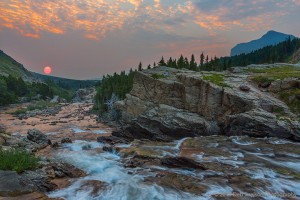
A trip to the Palouse is not complete without an excursion to central Washington to photograph Palouse Falls. The ancestral Palouse river flowed through the currently dry Washtucna Coulee to the Columbia River. During the end of the most recent Ice Age, glaciers had advanced from Canada into northern Washington and Idaho, and glacial lakes were impounded at the margins of these ice blocks. The largest known at that time was Lake Missoula, which catastrophically emptied because of a failure in an ice dam. A huge wall of floodwater cascaded down across the Columbia River valleys and carved the scablands, removing the loess and some of the basalt layer beneath. The Palouse Falls and surrounding canyons were created when the Missoula Floods overtopped the south valley wall of the ancestral Palouse River, diverting it to the Snake River by erosion of a new channel. It was difficult to photograph the deep canyon. I am afraid of heights, yet I pushed my tripod legs to the edge of the cliff for the image below, and I waited an hour or two for the sky to grow more interesting. I wanted to get the extent of the carved channel and as much of the plunge pool as possible. Since the sunset had been at my back, I waited until twilight to get some color in the sky. If I had more time in the area I would have returned on a day with greater potential for more clouds in the sky.

I have returned with more images than I could possibly share, and as of now I am too close to the capture to be a good judge of what is a good or bad photo. I will be creating a gallery of my images and will no doubt be adding to it as I continue to work my way through the images, as well as weaning them down to just my favorites in the next few months. Thank you for reading my post!
Susan A Huff
18 Jul 2021Your pictures are amazing! And earlier exploration of the Channeled Scablands, Grand Coulee, and the geology of the Missoula Floods prompted us to return to visit the Steptoe region of SE Washington earlier this year; it is, indeed, awe inspiring.
Max Howe
7 Apr 2020Thanks for sharing photos, sitting in Australia during the COVID 19 lockdown, great way to pass the time.
Deb Snelson
8 Apr 2020Thanks for taking time to look – stay safe!
Jerry
22 Nov 2019Sorry, forgot to add, your photos of Steptoe are great, used to live not far from there in St. John back in the late 50’s.
Deb Snelson
16 Dec 2019Thanks, Jerry! Beautiful area, I thoroughly enjoyed photographing Steptoe!
Jerry
22 Nov 2019Since 2010 my wife and I would take vacation in August. Each time we took one grand child, oldest to youngest. We visited such places as the Columbia River near Vantage, WA; Yellowstone and Devil’s Tower, WY; Mt. Rushmore, Deadwood, Rapid City, SD; The Redwoods, El Capitan, CA; Grand Canyon, AZ; Which we weren’t see all of because three days is not enough time. Dinosaur Nat. Monument, Arches Nat. Monument Utah and 4 Corners. We returned home from Utah via Twin Falls, ID; where, along the Snake River the depth of ancient volcanic activity just boggles the mind. The river bottom at Utah’s Dinosaur Monument is a sight to be seen. Approximately 147 million years ago was a scene out of the killing fields. Thousands of animal bones embedded in rock (river bottom) now tilted up about 70 degrees was dug out of the side of a hill and preserved when a building was built around it – imagination runs wild…
Tina Pecht
7 Jul 2015Outstanding captures, Deb! Nice variety of images/scenes. Love the crop duster one! The Cotswolds, in England, is where I first saw rapeseed fields. Stunning!
Deb Snelson
7 Jul 2015Thank you Tina! I saw my first rapeseed fields in Ireland, but this was the first chance I had to really walk around between the fields to get a variety of images. I’m so happy you enjoyed them!
Jim Dempsey
25 Jun 2015Superb series of images Deb, nice compositions with gorgeous light and colour, I love how you have used the tracks and trails to bring the viewer into the landscape.
Deb Snelson
25 Jun 2015Thank you for the kind comment Jim! Glad you like them!
Ron Nicol
24 Jun 2015Fantastic photos and very interesting commentary. Thanks for sharing!
Deb Snelson
25 Jun 2015Thank you Ron! I enjoyed writing it up to incorporate the geology which is always fascinating to me. Always seems to lay a foundation for what I am photographing.
Lise
24 Jun 2015thanks for sharing. Great photographs. Love the blog
lise
Deb Snelson
24 Jun 2015Thanks for the compliment, Lise! I know you’ve been to the area and are familiar with these scenes!
.Bruce Cavey
24 Jun 2015Thanks for sharing .
Deb Snelson
24 Jun 2015My pleasure Bruce!