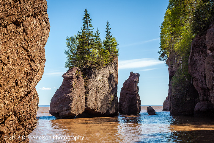
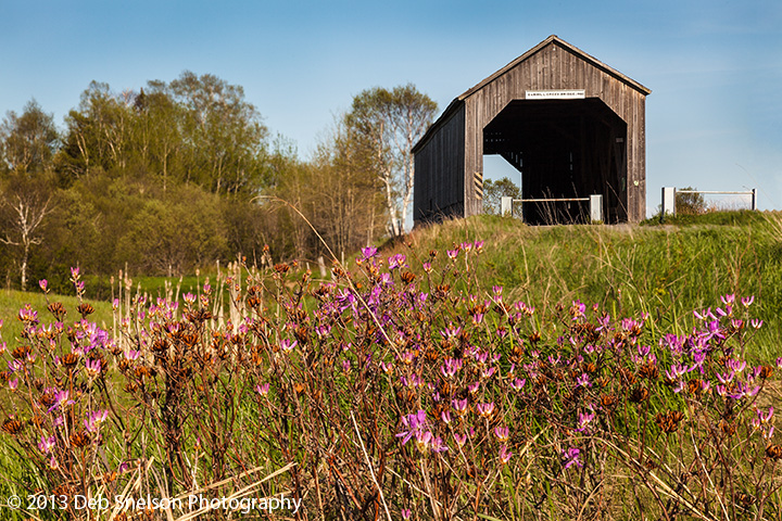
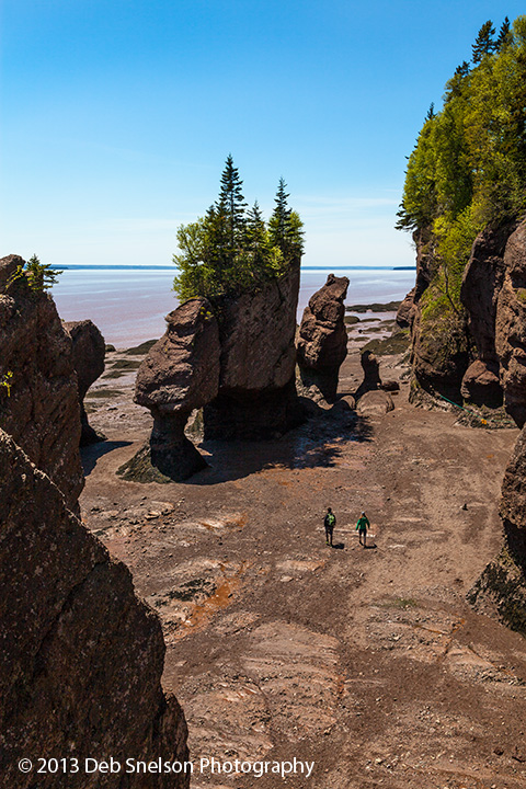
I said goodbye to Nova Scotia on May 28, 2013 and drove over the land bridge into New Brunswick. I was in a bit of a hurry because my destination was Hopewell Rocks at the headwaters of the Bay of Fundy where the largest change in water level between high and low tides occur. But I was blessed with a little bit of sunshine for this travel day. Hopewell Rocks Park is only open 9-5, and I wanted to catch both high tide and low tide. High tide would occur at 3PM and I managed to arrive near 3, but the hike down to the Bay meant I caught it just after the highest tide and water level was just starting to fall. Low tide would not occur until dark, so I headed south and west hugging the coastline, with a quick stop to capture the covered bridge at Sawmill Creek. As I drove I noticed the lavender-colored water of the Bay of Funday close to the shore – the muddy water from churning tides mixed with a reflected blue sky turned the water color lavender.
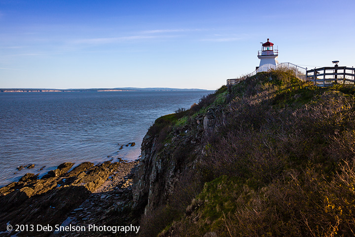
I continued on towards NB’s oldest lighthouse, Cape Enrage Light, c1847, perched high above sea level on a sheer cliff. The area gave me an overwhelming feeling of being alone. First, I passed no other cars on the country roads getting to the lighthouse. There were buildings all around, mostly abandoned barracks from the former Coast Guard Station (the lighthouse was automated in 1980), and signs indicating that there may be concessions in summer, but summer had not yet begun in Canada. It must have been this abandoned feeling that struck me, along with being so close to cliff edges and being all alone on an out-of-the way small peninsula, that pushed me to leave before sunset which was still 2 hours away.
I pushed on further west along the rugged coast to the fishing village called Alma. The harbour there is fascinating – because of the large tidal sea level variation, the fishing fleet must balance on their keels on nearly dry land during low tide, and can only go out fishing when the tide rises enough to float the boats so they can depart. Then they must be back in the harbour before the reversed tide makes the water level too low to navigate in to port – if they don’t make it back they spend the next 10-12 hours at sea! By this time in the early evening The large fishing vessels were all sitting upright on land in the tiny harbour, balancing with the aid of crates that appear to be attached by rope to each hull. I thoroughly enjoyed exploring this harbour in the golden sunset light!
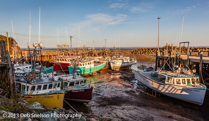
After a lovely night at Innisfree B&B (delightful host and hostess – highly recommended) I headed back to the Hopewell Rocks park the next morning and was able to walk on “the ocean floor” and photograph some wonderful hoodos that the steady erosion of the coast has left behind. On this day the ocean had receded 16.1 meters with the tide, truly a “Marine Wonder of the World”. It was fun to talk to the docent after his very educational tour about the geology of the strata exposed in the rocks. After departing Hopewell Rocks I headed southwestward again along the coastal road, and stopped once again at Alma. The boats were fairly much in the same place as the evening before, so I pressed onward.
My destination this evening was St Andrews by-the-sea which is near the far western boundary of New Brunswick with Maine. St Andrews is a “resort” town at the end of a peninsula jutting into the Bay of Fundy. I was attracted to the description online of a National Historic District with “streets steeped in turn of the century charm”. I had been looking forward to photographing this town at sunset, but I drove back into the rain, drizzle and overcast skies so typical of my entire Canadian adventure. I explored as I could and treated myself to a very nice fresh seafood dinner (well, I treated myself every night to a fresh seafood dinner…) and went to my B&B for the night. Now here was the tale of the day – The Inn on Frederick B&B is a 150 year old wooden mansion with the air of being haunted! It was perfectly maintained and clean, with most of the original features kept, but it just gave me a creepy feeling. My room was on the top floor, so up two very long elaborate staircases. I could see that I was the only guest in this wood-creaking place, and soon learned that the owner would not be staying on premises. So I had this huge mansion all to myself! I just hoped to not be visited by ghosts at midnight LOL.
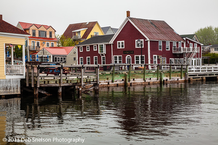
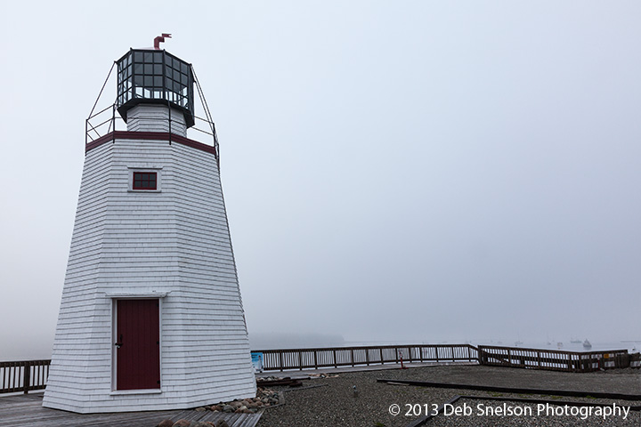
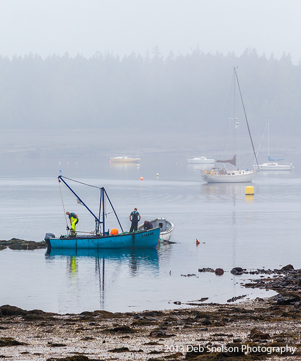
Another dismal morning on June 30th, with the beautiful Bay of Fundy shrouded in fog, but I explored the town a bit more and found a lighthouse, explored the bay floor which was exposed by the low tide, photographed a small dingy heading out to a moored fishing vessel, and found an open market with wonderful food treats and crafts. I will want to return to St Andrews, and even stay at the Inn on Frederick where I received the very best treatment and attention, and hope next time for some light!
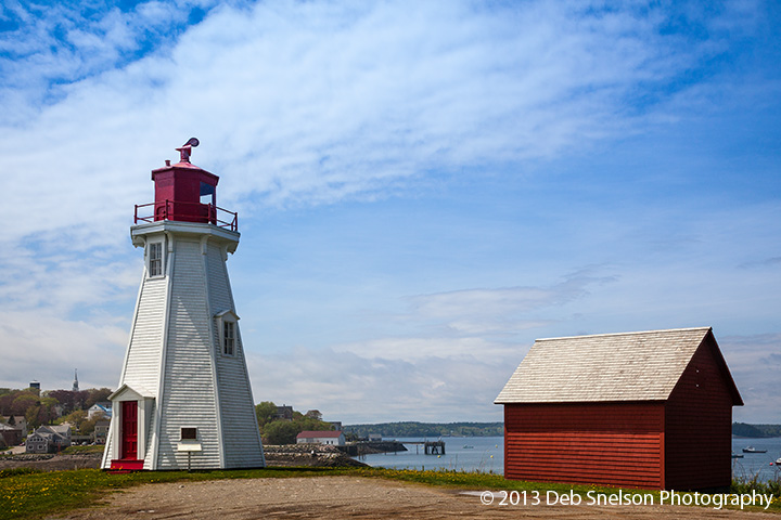
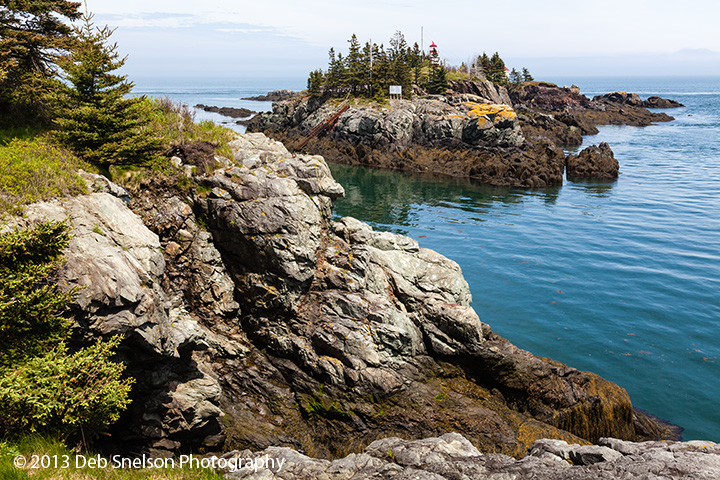
My next stop was a lighthouse on Campobello Island which was literally just south and even a bit east of where I stayed, but in order to get there I had drive north and west, cross the border into the USA at Calais, drive south and west in Maine along US1, then retreat back east through Lubec, the easternmost point of Maine, to cross the border back into Canada. A funny story on the way there – I put Campobello Island into my GPS, and it navigated me into Eastport Maine, which is on an island well off of Rt1. It took me to an old ferry launching site and told me to “drive 200 feet onto the ferry”. Only problem – there was no ferry at the end of the ramp! No matter what destination I entered into my GPS, including Lubec, I got the same directions – drive onto the ferry! I navigated back out to Rt1 and headed further south to Lubec and crossed the bridge into Canada. There are two lighthouses on tiny Campobello Island – Mulholland Lighthouse on the Lubec Narrows, and Head Harbour Lighthouse, also known as East Quoddy Light. I could not get over to the tiny island on which Head Harbour Light sits – it is only accessible during lowest tide – but the setting was beautiful.
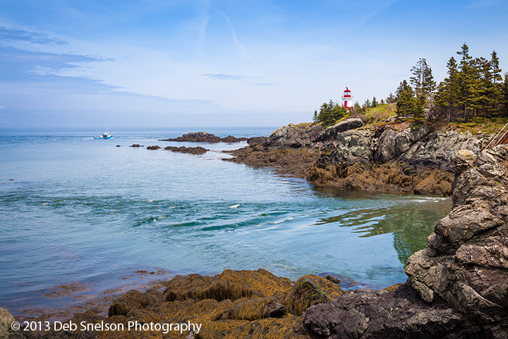
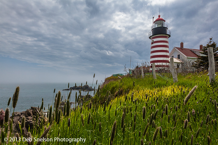
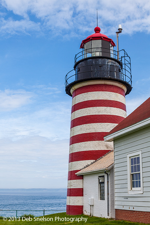
Onward to another lighthouse! The West Quoddy Lighthouse is boldly painted in red and white stripes and I knew I wanted a special view of it, so I scouted the area and decided to shoot from the cliff’s edge. This area was wooded, wild and not maintained. I stepped through the woods and decided to cross over an area of tall grasses and weeds to the edge, but quickly found myself sinking into the marshy field. I scrambled to backtrack and go around the field and over to the cliff’s edge. I wanted to get a bit closer to have a foreground element in the scene. Always scouting the best vantage point, I had to step ever so carefully on the few inches of land between brush, fence and the cliff’s edge, being careful not to look down and trigger my vertigo. I composed and shot as best I could and retreated back over the narrow ledge. I then thought of something I wanted to try and turned to go back. But when I looked back I saw that the cliff had actually eroded out from under that narrow trail, and the only thing I was walking across was a thin layer of soil and grasses suspended in the air. I didn’t go back. About an hour into my drive south along the coast of Maine the sky cleared and revealed a gorgeous blue sky. I turned around, and went back to the lighthouse to take the second shot shown below.
That night was spent in a miserable little town that was mostly comprised of hotels, restaurants and fast food places called Waterville, Maine. The next morning I got up early, ate a greasy breakfast, and headed home. I drove from Waterville straight through to my home in Barboursville Virginia – 757 miles, and over 15 hours including time spent in traffic in New York City.
Total mileage for the trip: 3416 miles.
Ron Nicol
25 Jul 2013You could have written a Stephen King novel on this trip. Looking forward to seeing the photos even though I know you were disappointed with the weather.
Ron
Deb Snelson
26 Jul 2013Thanks Ron for the comment and patience! When I got home from my journey I was just thankful that I faced so little adversity – much better a smashed thumb than a car accident!